On the afternoon of Saturday, 28 April 1770, a small, two-masted wooden boat (yawl), was hoisted out from the former Whitby collier His Majesty's Bark Endeavour, then under the command of Lieutenant James Cook, Royal Navy. At the time the Endeavour was anchored less than 2 miles off the Illawarra coast near present day Collins Point, Woonona, also known as Collins Rock. The yawl headed towards the shore, with its crew hoping to make contact there with the local Aboriginal people and collect specimens of flora and fauna. On board was Cook, scientists Joseph Banks and Daniel Solander, the Polynesian guide Tupia (Tupaia), and three others. Due to the rough surf along the coast that day, the yawl was not able to land. After observing the shoreline close at hand for a couple of hours, the crew returned to the Endeavour. Following a close encounter with Bellambi reef to the south, she set sail and continued her voyage north along the coast. The following day the bark entered Botany Bay, where Cook and members of his crew made their historic, first landing on Australian soil. The Endeavour remained at anchor there for 8 days, during which time the sailors, scientists and marines had a number of encounters with the local Aboriginal people, collected numerous scientific specimens and replenished stores.
The arrival of the Endeavour at Botany Bay is a significant event in the history of Australia, marking the British so-called "discovery" or "invasion" of a continent inhabited by an Indigenous population whose civilisation had evolved there over a period of more than 130,000 years, according to the latest scientific research, though for an eternity according to the Aboriginal Dreamtime. The day before the Botany Bay landing is not usually commemorated, though it is an important moment in the history of the Illawarra region. This article therefore discusses aspects of Cook's attempted landing at Woonona that Saturday afternoon in 1770.
There has been much debate by Illawarra local historians over the precise locality of Cook's first attempted landing on Australian soil on 28 April 1770. His own manuscript chart of the Illawarra coastline records the complex movements of the vessel off shore as it first passed by the region on 26 April and returned on 28 April. Therein it tacked a number of times and sought a location for the yawl to land. Unfortunately the map is not of sufficient detail to precisely identify the various beaches, headlands and bays located between major features such as Red Point and Point Solander, with the latter marking the southern entrance to Botany Bay. However, the chart is accurate enough to hazard a guess, and more especially so if accompanying written records and coastal profiles are also taken into account. The research by Edgar Beale into this matter during the 1960s is included in an appendix below and verifies that the attempted landing took place off Collins Point, Woonona, just to the north of the more prominent Bellambi Point.
James Cook, Chart of the coast of New South Wales, 1770. British Library, Add.Ms.31360f.45.
Cook's manuscript chart of this section of the east coast of Australia (reproduced above) was prepared during the voyage and shortly thereafter upon returning to England. It was first published as an engraving (extract reproduced below) in 1893 (Wharton 1893). At that point dates in civilian time and topographical names were added to Cook's original annotations, which primarily comprised fathom readings and some locality names, including Red Point and Botany Bay. The 1893 engraving does reveal the complex tacking manoeuvers by the Endeavor off the Illawarra coast between 26 and 28 April 1770. NB: The landing at Woonona is given therein as taking place on 27 April, which accords with the ship-board log record (i.e. naval time), wherein day dates were cited as from midday to midday.

James Cook, Chart of the Coast of New Holland
(extract) showing movements off the Illawarra coast, April 1770. Engraving published in 1893. Note that dates are given on this map in naval time (e.g. April 25),
not civilian time (e.g. April 26).
In both the manuscript and printed versions of Cook's map there is an amount of useful detail regarding the shoreline,
whereby he records the many small
bays which define the land north of Red Point and on towards Botany Bay. The northern Illawarra coastline is noted for its many small beaches bounded on the north and south by small points of land. Cook's chart is as accurate as it is because the bark
Endeavour had been built at Whitby in 1764 as a shallow draught coal transport, or collier. It was therefore able to work relatively close in shore without fear of grounding.
Thomas Luny, The Earl of Pembroke leaving Whitby harbour for the last time in 1768, prior to its conversion to HMB Endeavour, oil on canvas, circa 1790. Collection: National Library of Australia.
Cook had begun his sailing career aboard a Whitby collier and was
therefore familiar with it's capabilities. He had also developed skills
as a cartographer. As a result, his chart and logs provide detail in
regards to both the various tacking movements made by the vessel whilst
off the Illawarra coast, and also features such as an offshore reef in
the vicinity of
Bellambi, which he noted on the chart with a cross.
The definitive account of the search for the precise location of Cook's attempted landing is to be
found in the 1964 article by the aforementioned Edgar Beale, published in the Journal of the
Royal Australian Historical Society. It followed on previous work by
local historian C.W. Gardener-Garden dating back to 1952, which corrected even earlier
references to the site as being variously located to the south near Lake
Illawarra and Port Kembla, or to the north near Bulli. Both the
Gardiner-Garden and Beale accounts are reproduced below as appendices. During his research, Beale was also able to discover in the British Museum the original Illawarra coastal profile drawings by Endeavour crew member Sydney Parkinson. These were a significant addition to the story as they were in all likelihood made whilst the vessel was anchored off shore during the extended effort at an attempted landing by Cook and his crew in the yawl. Within the article Beale annotated the profiles and noted that they supported Gardiner-Garden's finding that Collins Point, Woonona, was the location of the attempted landing.
 |
| Sydney Parkinson, Coastal View Sketches [annotations by Edgar Beale], April 1770, British Museum. As published in Beale (1964). |
Accounts of what happened at Woonona on the afternoon of 28 April 1770 have, to date, presented the European view, as no first-hand, written records exist which provide an Aboriginal perspective. However, during the 1990s this author was informed by a member
of the local Aboriginal community - Jeff Timbery, a descendant of the Timbery clan - that, according to oral tradition, when the Endeavour first sighted
the east coast of Australia at Point Hicks on 20 April 1770, the vessel in turn was closely observed by Aboriginal people. This was not, in all likelihood, the first time a sailing ship had visited the east coast of Australia, though it was the first to be officially recorded and published in any detail.
A group of Illawarra and South Coast (Yuin) people shadowed the Endeavour as it headed
north towards Botany Bay, providing information to their fellow coastal Aboriginal communities along the way. This may explain the fact that upon entering Botany Bay on the morning of 29 April the Endeavour was greeted by numerous Aboriginal people on the shoreline shouting Wirra wirra wai! ["Go Away! Go Away!"] - an antipathy which to date has not been explained. Though we will probably never have the complete story from both the Aboriginal and European perspectives, it is nevertheless worth considering the inclusion of both accounts, where they exist, in any discussion of these events. As such, this blog utilizes information provided by original resources such as James Cook's ship log, Joseph Banks' personal journal, the records kept by various members of the Endeavour crew - which tended to copy Cook's accounts - and the known Aboriginal oral history tradition.
-----------------------
Summary of events
The following summary of
events as they occurred at Woonona on the afternoon of 28 April 1770 has been compiled from the original accounts (reproduced below) and subsequent research. This summary brings
together relevant information to produce a simple narrative which covers the period from noon to approximately 6 p.m., at which point the
Endeavour set sail and headed north. There is some discrepancy between the extant accounts, especially in regards to the precise timing of various events. In such cases the author has chosen those points which are most commonly referred to or precisely described. For example, one journal records Cook and the yawl returning to the
Endeavour at 4.30 p.m, whilst a number of others state 5 p.m. The latter time is therefore included in this summary account. There is also some doubt as to the precise location of the events, though research to date points to off Collins Point near Woonona, and north of Bellambi Reef to the south, as the most likely placement of the
Endeavour that afternoon. The area on the north side of Collins Point, at the outlet to Collins Creek, is also the probable location of the Aboriginal camp site and near shore collection of canoes variously seen by the yawl's crew that afternoon. The Colin Hazelhurst Google Earth animation included above is a good supplement to the following attempt at a precise summary of events.
Saturday, 28 April 1770
Noon / 12 p.m.: Lieutenant Cook takes a reading of the position of the
Endeavour as he continues to chart the coastline through close-in observation.
The vessel is at latitude 34° 21', 4 or 5 miles out to sea and 3 leagues (9 miles / 16.5 km) north of Red Point (Hill 60, Port Kembla). This places it off present-day Collins Point, Woonona [
Google Maps link].
The sea is calm with light winds from the north and north east. There is a prevailing 2 knot current moving in a southerly direction.
The crew takes dinner (lunch), which usually occupies approximately 90 minutes.
Scientist Joseph Banks observes a single fire on shore, evidencing the presence of the local Aboriginal community.
The
Endeavour drifts westerly, closer to shore and Collins Point, in the direction of what appears to be a smallish bay, or long beach, on the south side between it and Bellambi Point.
Artist Sidney Parkinson sketches a coastal profile whilst the
Endeavour lies off shore.
1 p.m.: The
Endeavour tacks, or turns in the opposite direction, under gentle breezes and clear weather. The course varies from W.N.W. to E.S.E. during tacking. It maintains its position off Collins Point.
The
Endeavour is now closer in shore, within 1 to 2 miles.
The Endeavour replica close in shore.
From on board, the crew observe a group of 4 or 5 Aboriginal men walking briskly along the shoreline.
Among the group there are 2 men carrying a canoe on their shoulders.
Cook and Banks assume the natives are going to launch their canoe and come out to the
Endeavour, but this does not occur.
Tupaia, Aborigines in canoes, with one man using a garrara spear to catch a fish, Botany Bay, circa 29 April 1770. Collection: British Museum.
1.30 p.m.: After dinner [lunch] Cook proposes landing on shore, to meet up with, and hopefully speak to, the local people.
The pinnace and yawl are prepared, and both launched from the
Endeavour.
The pinnace quickly takes on water and is hauled back on board.
Preparations are made to the yawl for the excursion and to accommodate the landing party.
2 p.m.: Winds N.E. to N. The
Endeavour tacks again. Course W.N.W by N.
The twin-masted yawl, with Cook, Banks, Solander and 4 rowers including Tupaia on board, heads towards the shore and the place where a group of Aboriginal men are seen, on the northern side of Collins Point.
Three native men - who are noted as appearing naked and very black skinned - sit on the rocks (?Collins Point) near the beach looking at the approaching vessel and apparently waiting to meet the crew.
As the yawl comes to within a quarter of a mile of the men on the rocks, the latter get up and move off into the nearby bush.
The crew in the yawl look for a place to land.
3 p.m. - 5 p.m.: As they pass close to shore, Cook and his companions see 4 small canoes on the beach, which the natives have left there.
Adjacent to the canoes near the shore is a small wig-wam like structure, or hut.
Louis Auguste de Sainson, Native huts, Jervis Bay, 1826. Coloured lithograph.
The crew is unable to find a landing place due to the great surf which is all along the coast at this time.
During this period the
Endeavour stands off and on shore, in 9 to 14 fathoms of water, and within the bay area between Collins Point and Bellambi Point to the south.
On board, the draughtsman Sydney Parkinson prepares coastal profile drawings covering the Illawarra from Red Point (Port Kembla) in the south to Broker's Nose (Corrimal) and Woonona / Bulli in the north. Mounts Kembla and Keira can be seen in the middle distance.
On the shore behind the beach the yawl crew see a stand of trees, including cabbage palms, with no underwood. They liken it to a gentleman's park.
Both north and south of Collins Point are large back-beach lagoons fed by fresh water creeks running down off the Illawarra escarpment across the thin coastal plain towards the sea. These water bodies are not referred to in the various logs and reports.
The canoes which are observed hauled up on the beach are used for fishing both in the ocean near-shore, and within the nearby creeks, lagoons and Lake Illawarra to the south.
The yawl continues to sail up and down the near shore coastline, looking for a spot to land and observing the local landscape.
Due to the rough surf, and likelihood of the yawl overturning if caught by a large, breaking wave, Cook decides to return to give up on an attempted landing.
 |
| Location map from Beale (1964), showing the approximate position where the Endeavour was anchored as Cook and his party attempted to land near present-day Collins Rock on 28 April 1770. |
5 p.m.: The
Endeavour tacks.
Cook and party return to the
Endeavour.
The yawl is hoisted in.
The weather turns calm (i.e., the wind dies down) and the
Endeavour is now located about 1 1/2 miles off shore in 11 fathoms of water.
The
Endeavour drifts south towards the breakers of Bellambi reef wherein Cook perceives danger.
Fortunately, a wind picks up from the W.S.W. and moves the
Endeavour away from the reef.
6 p.m.: The
Endeavour sets sail and heads out to sea in an easterly, then northerly, direction, skirting the coastline as darkness falls.
12 a.m.: Light wind, clear weather as the
Endeavour sails north along the coast.
Sunday, 29 April 1770
2-3 a.m. In the course of the night many camp fires are seen along the shore.
6 a.m. The
Endeavour arrives off Botany Bay. The pinnace is launched to survey the entrance, before the
Endeavour commences entry just after noon.
3 p.m.: The
Endeavour drops anchor in Botany Bay.
--------------------------
The Accounts from 1770
Surviving accounts of the voyage by Lieutenant Cook, botanist Joseph Banks and other members of the crew of the
Endeavour are significant in that they contain the first published European observations on the Aborigines of the region, along with precise descriptions of the Illawarra escarpment and adjacent landscape. Whilst many of the accounts are repetitive, in combination they provide a relatively detailed picture of daily events. Extracts are reproduced below relating to both the native people and what happened at Woonona on 28 April 1770.
James Cook’s Journal
The following extracts are taken from the journal of Lieutenant James Cook, now in the collection of the National Library of Australia (Wharton 1893). Note that the account for the morning of the 28th is included with the entry for the 27th, according to naval time tradition. Cook used naval time, in which the day begins and ends at noon, rather than midnight. Others, such as Banks, used civilian time (midnight to midnight). The first description of the local Aboriginal people was made when the
Endeavour was off the coast near Pigeon House mountain, south of Ulladulla, two days after sighting land:
Sunday, 22
nd April [1770]: ....After this we steer’d along shore N.N.E., having a gentle breeze at S.W., and were so near the shore as to distinguish several people upon the Sea beach. They appeared to be of a very dark or black Colour; but whether this was the real Colour of their skins or the Cloathes they might have on I know not.
[The next day the
Endeavour was sailing along the coast between Jervis Bay and Red Point (Port Kembla), near Wollongong]
Wednesday, 25
th April: ....In the Course of this day’s run we saw the Smoke of fire in several places near the Sea beach.
[The following observations were taken off the coast near Bass Point (Shellharbour) and Red Point (Port Kembla)]
Thursday, 26
th April: Saw several smokes along shore before dark, and 2 or 3 times a fire.
[On Friday, 27
th April, the
Endeavour sailed as far north as just to the south of Botany Bay, before heading south back towards the Illawarra to carry out further charting and coastal profiling.]
Friday, 27
th ......at Noon
we were by Observation in the Latitude of 34 degrees 21 minutes South,
Red Point bearing South 27 degrees West, distant 3 Leagues. In this
Situation we were about 4 or 5 Miles from the land, which extended from
South 19 degrees 30 minutes West to North 29 degrees East.
[The first attempted landing occurred near Collins Point, Woonona, on 28 April]
Saturday 28
th In the
PM hoisted out the Pinnace
and yawl in order to attempt a landing but the Pinnace took in the water
so fast that she was obliged to be hoisted in again to stop her leakes -
At this time we saw several people a shore four of whome where carrying
a small boat or Canoe which we imagined they were going to put into the
water in order to come off to us but in this we were mistaken. Being now not above two Miles from the Shore M
r Banks D
r
Solander Tupia and myself put off in the yawl and pull'd in for the
land to a place where we saw four or five of the natives who took to the
woods as we approached the Shore which disapointed us in
our ^the expectation we had of getting a near view of them if not to speak to them but our disapointment
^was heighten'd when we found that we no where could effect a landing
by reason of the great surff which beat every where upon the shore - we
saw hauld up upon the beach 3 or 4 small Canoes which to us appear'd
not much unlike the small ones of New Zeland, in the woods were several
trees of the Palm kind and no under wood and this was all we were able
to observe
of the country from the boat
after which we returnd to the Ship about 5 in the evening. At this time
it fell calm and we were not above a mile and a half from shore in a 11 fathom water
and within some breakers that lay to the southward of us but luckily
a light breeze came off from the land which carried us out of danger
and with which we stood to the northward....
Robert Marsh Westmacott, Bulli from the Coal Cliffs, watercolour, c.1835. National Library of Australia. View of the northern Illawarra coastline looking south towards Bulli, with Mounts Keira and Kembla in the distance on the right and Red Point (Port Kembla) in the far distance on the left. A group of Aborigines with spears stand on the rocky platform as the surf breaks against the edges.
[After the unsuccessful attempt to land, the Endeavour sailed on north and arrived at Botany Bay the following day, around 6 a.m.]
Joseph Banks’s Journal
Joseph Banks, naturalist aboard the
Endeavour, kept a detailed journal during the voyage. The following extracts from it deal with the Illawarra and South Coast Aborigines as observed between 20-27/28 April 1770:
[On 20/21 April the
Endeavour was sailing north between Cape Howe and Cape Dromedary]
20. The countrey this morn rose in gentle sloping hills which had the appearance of the highest fertility, every hill seemed to be cloth’d with trees of no mean size; at noon a smoak was seen a little way inland and in the Evening several more.
[On 21/22 April the
Endeavour was sailing north between Cape Dromedary and Bateman’s Bay]
21. In the morn the land appeard much as it did yesterday but rather more hilly; in the even again it became flatter. Several smoaks were seen from whence we concluded it to be rather more populous; at night five fires.
[On 22/23 April the
Endeavour was off Point Upright, north of Bateman’s Bay and south of Pigeon House Mountain]
22. The Countrey hilly but rising in gentle slopes and well wooded. A hill was in sight which much resembled those dove houses which are built four square with a small dome at the top. In the morn we stood in with the land near enough to discern 5 people who appeard through our glasses to be enormously black: so far did the prejudices which we had built on Dampier’s account influence us that we fancied we could see their Colour when we could scare distinguish whether or not they were men.... Since we have been on the coast we have not observed those large fires which we so frequently saw in the Islands and New Zealand made by the natives in order to clear the ground for cultivation; we thence concluded not much in favour of our future friends...
[On 23/24 April the
Endeavour was becalmed off the region of Pigeon House Mountain. Aboriginal tradition States that members of the Endeavour crew came on shore this day, though there are no records to verify this, apart from Banks' comment below]
23. Calm today, myself in small boat but saw few or no birds .... The ship was too far from the shore to see much of it; a larger fire was however seen than any we have seen before...
HMB Endeavour replica at sea, circa 2001.
[On 24/25 April the
Endeavour was sailing north in the region of Jervis Bay]
24. The wind was unfavourable all day and the ship too far from the land for much to be seen; 2 large fires however were seen and several smaller....
[On 25/26 April the
Endeavour was sailing north between Shoalhaven and Red Point]
25. Large fires were lighted this morn about 10 O’Clock, we supposed that the gentlmen ashore had a plentifull breakfast to prepare ... In the even it was calm. All the fires were put out about 5 O’Clock...
[On 26/27 April the
Endeavour was off Illawarra and to the north]
26. Land today more barren in appearance than we had before seen it: it consisted chiefly of Chalky cliffs something resembling those of old England; within these it was flat and might be no doubt fertile. Fires were seen during the day the same as yesterday but none so large.
[On 27/28 April the
Endeavour was off northern Illawarra, in the region of Bulli / Woonona, and an attempt was made to land]
27. The Countrey today again made in slopes to the sea coverd with wood of a
tolerable growth tho not so large as some we have seen. At noon we
were very near it; one fire only was in sight. Some bodies of 3 feet
long and half as broad floated very boyant past the ship; they were
supposd to be cuttle bones which indeed they a good deal resembled but
for their enormous size. After dinner the Captn. proposed to hoist out boats and attempt to land, which gave me no small satisfaction; it was done accordingly but the Pinnace on being lowered down into the water was found so leaky that it was impractical to attempt it.
Four men were at this time observed walking briskly along the shore, two of which carried on their shoulders a small canoe; they did not however attempt to put her in the water so we soon lost all hopes of their intending to come off to us, a thought with which we once had flattered ourselves. To see something of them however we resolvd and the Yawl, a boat just capable of carrying the Captn, Dr Solander, myself and 4 rowers was accordingly prepared. They sat on the rocks expecting us but when we came within about a quarter of a mile they ran away hastily into the countrey; they appeard to us as well as we could judge at that distance exceedingly black. Near the place were four small canoes which they left behind. The surf was too great to permit us with a single boat and that so small to attempt to land, so we were obliged to content ourselves with gazing from the boat at the productions of nature which we so much wishd to enjoy a nearer acquaintance with.
The trees were not very large and stood separate from each other without the least underwood; among them we could discern many cabbage trees but nothing else which we could call by any name.
In the course of the night many fires were seen.....
[Banks and some of the crew of the
Endeavour made a successful landing at Botany Bay the following day, Sunday, 28/29 April 1770.]
Sydney Parkinson, Botany Bay sketches, April 1770. Collection: British Museum.
-------------------------------
Lieutenant James Cook's Private Log
[Transcribed in Historical Records of New South Wales, 1(1), 17-18.]
Saturday, 28 April.
12 p.m. Little wind and clear weather. Extremes of the land from S. 19° 30' W. to N. 29° East. Red Point, So. 27° West. Dist., 9 miles. Dist'ce off shore , 4 or 5 miles. Lat'd ob'd, 34° 21'.
1 p.m. Tk'd. Gentle breezes and clear weather.
Tk'd and hoisted out the pinnace and yawl, but was obliged to hoist in the pinnace again to stop her leaks. After this I went in shore with the yawl in order to land, but this I was not able to effect on account of the surff, and therefore return'd again to the ship.
2 p.m. Tk'd.
5 p.m. Tk'd.
6 p.m. Course - East. Wind - W.S.W.
11 p.m. Light wind and clear wea'r.
2 a.m. Saw several fires along shore.
6 a.m. Discovered a bay, which we plyed up for.
----------
Lieutenant James Cook's Official Log
[Transcribed in Historical Records of New South Wales, 1(1), 95-6. Most likely written up by somebody other than Cook, though based on his original Log.]
Saturday, 28 April.
Noon Latitude observed 34° 21' South. Ext's of the land from S. 11° W. to N. 20°. Distance off shore, 4 or 5 miles.
1 p.m. Moderate breezes and fine pleasant weather.
Tacked ship. Brought too and hoisted out the yawl.
2 p.m. Tacked. Distant off shore 2 or 3 miles. The captain, Mr. Banks, &c., went away in the yawl. 17 fathom water.
5 p.m. Tacked ship. The yawl returned, the captain not being able to land for ye surf.
Extent of the land from N.N.E. to S. Distant off shore 4 or 5 miles. From 11 to 13 fathom water.
8 p.m. 27 fathom.
9 p.m. 32 fathom.
3 a.m. Sounded 61 fathom. Saw several fires ashore.
4 a.m. Moderate and fair.
5 a.m. Sounded 58 fathom. Out 1 reef.
6 a.m. Saw a bay.
----------

Samuel Atkins, HMB Endeavour off the coast of New Holland [1770], watercolour, c.1794, National Library of Australia. Two of the vessel's small craft - longboat, pinnace and yawl - can be seen in front of the bark.
Lieutenant James Cook's Log (Palliser Copy)
[Transcribed in Historical Records of New South Wales, 1(1), 293-4.]
Saturday, 21 April - 2 p.m., Saw the smoock of fires on
several places upon the land; a sure sign of its being inhabited.
Sunday, 22 April - 2 p.m., Saw a smoak on ye shore.... 11
p.m., Saw a fire ashore.... 8 a.m., Saw severell people on the beach.
Wednesday, 25 April - Noon, Severell smokes seen along
shore in the course of this day's sail.
Saturday, 28 April
Noon - Little wind and clear weather. Extremes of the land from S. 19° 30' W. to N. 29° E. Red Point S 27° W distance 9 miles. Distance off shore 4 or 5 miles. Latitude observed 34° 21' S.
1 p.m. - Gentle breezes and clear weather. Tacked.
2 p.m. - Tacked and hoisted out the pinnace and yawl, but was obliged to hoist in the pinnace again to stop her leaks. After this I went in shore with the yawl in order to land, but this I was not able to effect on account of the surf, therefore returned again to the ship.
3 p.m. - Tacked.
5 p.m. - Tacked.
12 p.m. - Little wind and clear weather.
2 a.m. - Saw severell fires along
shore.
----------
Sydney Parkinson's Journal
[Parkinson was the botanical draughtsman on board the Endeavour. His also took sketches and drew coastal profiles. Parkinson's journal uses civilian time.]
On the 20th, we sailed along shore with a fine brisk breeze, but we
found no harbour. The land appeared rather level, with here and there a
gentle ascent covered entirely with wood, some of which appeared large.
About noon we saw some smoke ascending out of a wood near the sea tide.
Latitude 36° 51'.
On the 21st, we had fine clear weather, and a brisk gale: the
coast appeared much the same as it did the day before, excepting that it
was rather lower. In the evening the land appeared very low and strait,
stretching away to the N.E. and was well covered with trees. We saw
some clouds of smoke rising from them a good way up the country, but we
found no harbour. Latitude 35° 51'.
On the 22d, the coast made a good view, being flat, level, and
covered with verdure. The hills within land were remarkably flat: we
discovered five men upon them, through our glasses, who were quite
naked. It is probable they live upon the produce of the earth, as we did
not see any canoes, and the coast seems to be unfavourable for fishing.
Latitude 35° 27'.
On the 25th, we were in latitude 34° 22'. The weather was very
fine, but we were often becalmed. The land appeared still flat,
remarkably level, and strait on the top. We saw several fires along the
coast lit up one after another, which might have been designed as
signals to us.
On the 27th, in the morning, the wind being against us, we stood
off and on shore. At noon, being about one mile from land, some of our
men were sent on shore in a boat, which soon returned, not being able to
land for the surf, which ran very high all along the coast. They
espied three men, sitting on the beach, who were naked, and of a very
dark colour; but, on the boats approaching nearer toward them, they fled
into the woods. Our people also discovered several canoes drawn upon
the beach, and a kind of house or wig-wam adjacent. We also, from the
ship, saw five men walking, two of whom carried a canoe on their
shoulders. The country looked very pleasant and fertile; and the trees,
quite free from underwood, appeared like plantations in a gentleman's
park.
----------
Lieutenant Zachary Hicks's Journal
[Transcribed in Historical Records of New South Wales, 1(1), 178.]
Saturday, 21 April - saw a smoke on ye shore.
Sunday, 22 April - saw some Indians on shore.
Saturday, 28 April 1770 - Moderate breezes and pleasant. At 2 p.m. sounded 17 fathoms. Ye captain went away in ye yawl, but could not land for ye surf. At 5 p.m. extremes of land from N.N.E. to S.; off shore 5 miles. Sounded 13 fathoms...
----------
Gunner Stephen Forwood's Journal
[Transcribed in Historical Records of New South Wales, 1(1), 193.]
Saturday, 21 April - 1 p.m., saw a smoke on shore... 6
p.m., a smoke on shore.
Sunday, 22 April - 9 a.m., saw several Indians on shore.
Tuesday, 24 April - a bluff head near which were two
large smokes, N. 72 W.
Wednesday, 25 April - 10 a.m., saw several smokes on
shore.
Thursday, 26 April - 8 p.m., saw a fire on shore.
Saturday, 28 April 1770 - 1 p.m. moderate breezes and fair pleasant weather; hoisted out the pinnace and yawl, but the pinnace being so leaky was obliged to hawl her in again; tacked ship; the captain went on shore in the yawl. 5 p.m. the yawl returned; the surf prevented her landing; extremes of land from N.N.E.to S; distance off shore, 4 or 5 miles. 3 a.m. saw several fires along shore.
----------
Richard Pickersgill's Journal
[Transcribed in Historical Records of New South Wales, 1(1), 213-4.]
Saturday, 21 April - P.M., saw a smoke on shore.
Sunday, 22 April - saw several smokes on shore; ... saw a
fire on shore... A.M., as we stood along shore we saw four or five of the Indians
sitting near the fire; they appeared to be naked and very black, which was all we could
discern at this distance.
Wednesday, 25 April - At 10 a.m. saw several columns of
smoke on the shore, which had a very pleasant appearance.
Friday, 27 April - At noon off shore 4 or 5 miles; saw
several smokes. Latitude observed 34° 22'.
Saturday, 28 April - Moderate breezes and pleasant weather. At 2 p.m., being within 2 miles of the shore, tacked and hoisted out the yawl; the captain, Mr Banks, &c., went towards the shore; as we stood in we had regular soundings from 14 to 9 fathoms; standing off and on shore under an easy sail; the bay is covered well to ye southward by a low patch of red earth, which looked like islands, and runs a great way into the sea. At 5 p.m. the boat returned, having
been close to the shore, but could not land for the surf; they saw two people who came
down to the beach, but soon after retired to the woods, where they saw them no more;
the shore appeared very pleasant, with tall trees, having little or no underwood,
and some fine plains in the woods; they saw some trees like cabbage-trees, a hut, and
two small boats, ill made. At 6 p.m. hoisted in the boat and made sail out to sea; in the night saw several fires along shore.
----------
Able Seaman Charles Clerke's Journal
[Transcribed in Historical Records of New South Wales, 1(1), 231.]
Saturday, 21 April - saw a smoke on ye shore.
Sunday, 22 April - saw some Indians on shore.
Saturday, 28 April 1770 - Moderate breezes and pleasant. At 2 p.m. sounded 17 fathoms; ye captain went away in ye yawl, but could not land for ye surf. At 5 p.m. extremes of ye land from NNE to S; off shore 5 miles; sounded 13 fathoms.
----------
Master's Mate Francis Wilkinson's Journal
[Transcribed in Historical Records of New South Wales, 1(1), 238.]
Saturday, 21 April - saw several smokes on shore.
Sunday, 22 April - saw a smoke on shore... At 10 p.m. saw
a fire on shore.... At 9 a.m., saw several Indians on shore, distance 4 or 5 miles.
Wednesday, 25 April - At noon ... saw several smokes on
shore.
Saturday, 28 April - Moderate breezes and fine clear weather. Half past 1 p.m. tacked and brought to and
hoisted out the boars. Half past 2 p.m. tacked off shore 2 or 3 miles. The captain, Mr Banks
&c. went away in the yawl. At 4 p.m. tacked; the yawl returned, the captain not being able to land for the surf; extremes from NNE to S, off shore 4 or 5 miles. At 3 a.m. saw several several
fires on shore.
----------
Midshipman John Bootie's Journal
[Transcribed in Historical Records of New South Wales, 1(1), 252.]
Sunday, 22 April - At 3 p.m., a smoke ashore.... A.M.,
saw several Indians on the beach.
Wednesday, 25 April - saw several smokes ashore.
Saturday, 26 April - At 6 p.m., saw a fire ashore.
Saturday, 28 April - Moderate and pleasant weather; brought to and
hoisted the yawl out; standing into a bay. At 2 p.m. tacked 2 or 3 miles off shore; the captain, Mr Banks
&c. went away in the yawl. At 5 p.m. tacked; the yawl returned; the
surf had prevented them landing; extremes from NNE to S, 4 or 5 miles
off shore. At 3 a.m. saw several several
fires along shore.
----------
Astronomer Charles Green's Journal
[Transcribed in Historical Records of New South Wales, 1(1), 270-1.]
[Dates have been corrected to allow for travelling east]
20 April - 3 p.m., saw a smoke ashore.
21 April - saw a smoke ashore.... 9 a.m., 4 or 5 miles
off shore; saw several Indians thereon.
23 April - Pigeon-house Hill, S. 62 W.; a bluff head,
near which were two large smokes.
24 April - 11 a.m., saw several smokes ashore.
25 April - 7 p.m., saw a fire ashore.
27 April - 1 p.m. moderate breezes and pleasant weather; tacked; brought to and hoisted out ye yawl. 2 p.m. tacked; 2 or 3 miles off shore; captain &c. went away in the yawl. 5 p.m. tacked; the yawl returned - the surf had prevented their landing; extremes from NNE to S; 4 or 5 miles off shore. 12 midnight moderate and fair. 3 a.m. saw several several fires ashore.
---------------------------------------
Plaques and Memorials
At some point during the 1950s a memorial to the attempted landing was erected in the form of a plaque which was cemented into place, possibly at Waniora Point, near Bulli swimming pool, directly north of Collins Pont. This first plaque lists Bulli as the approximate landing site.
Captain Cook commemorative plaque, Bulli, circa 1960.
This plaque most likely predates the work of Gardiner-Garden (1952-9) and Beale
(1964) wherein Collins Point, Woonona, is identified as the closest
point to the attempted landing. In 1979 local Bulli historian William A. Bayley reported in the
Illawarra Historical Society Bulletin on a second Captain Cook memorial erected at Collins Point around 1970, in association with the Cook Bicentennial celebrations of that year.
Captain Cook commemorative memorial, Collins Pont, Woonona, circa 1990.
Bayley's report read:
CAPTAIN COOK MEMORIAL
The historic marker erected by the Rotary Club of Bulli at the point at Bulli / Woonona known variously as Flat Rock, Collins Rocks, Collins Point and now confirmed by the Central Mapping Authority as Collins Rock, to celebrate the Captain Cook Bi-centenary of his first attempted landing in Australia, has lost its gilt inscription through action of wind and water. The Bulli Rotary Club has advised our society that it intends to restore the marker; the work to be carried out by the Community Service Committee in the near future. The monument is visited by many bus loads of visitors to Illawarra and of Illawarra school students regularly and serves a very valuable purpose for tourists and historical study. Captain Cook was there on April 28, 1770.
During 2008 a commemorative plaque and artwork was put in place on the roof of the Woonona bathers pavilion, overlooking Collins Point. This was an initiative of Wollongong City Council.
Plaque commemorating Cook's attempted landing in 1770, Woonona, 2008.
Summary
There are four significant events in the story of
HMB Endeavour and its encounter with the east coast of Australia during 1770: 1) the attempted landing at Woonona, where Cook and his crew were driven back by a large surf; 2) the visit to Botany Bay; 3) the careening near present day Cooktown, Queensland, and 4) Cook's taking possession in the name of the King at Possession Island, off the coast of Queensland. The attempted landing at Collins Point in 1770 by Captain James Cook and members of the crew of
HMB Endeavour is a landmark in the history of the Illawarra region. It is the first verifiable incident of close contact between Europeans and the local Aboriginal population, even though that contact was merely visual for both parties. In addition, the various logs and journals of the
Endeavour expedition record, for the first time, aspects of the local landscape and way of life of the Aboriginal population.
The Cook expedition marked the commencement of the European colonisation of Australia and the resultant impact it was to have on the Indigenous people who have occupied the area for in excess of 130,000 years. The journey of the
Endeavour along the New South Wales coast was a major event for the local Aboriginal people and was to culminate in the arrival of the First Fleet at Botany Bay and Port Jackson in January 1788.
The
Endeavour is the first European
vessel we know of for certain to have make such an attempt. As noted above, it was a
Whitby collier, referred to recently by a British historian as
"the coal tanker of its day" (Collingridge 2008). Built in 1864 to take coal from Newcastle to London, the then
Earl of Pembroke was a strong ship, with shallow draught and stable at sea, if somewhat slow. She went on to serve Cook and his crew well in their adventure. It is ironic that a Whitby collier should be moored off the Illawarra coast during April 1770, for just over a century late coal mining would become the
economic life blood of the region. The first mines opened on the Illawarra escarpment during the late 1860s and mining of the black diamonds continues through
to the present day. The sight of coal carriers and
tankers waiting off the coast to load or unload their cargo of coal is one that is regularly observed by the local community.
It should
also be noted that the other internationally significant aspect of the
region - its surf - was the very thing that denied the Illawarra a place in
Australian history in connection with the voyaging and discoveries of
Captain James Cook. If the surf had not been "up" that day, then things may have been very different.....
Elizabeth Brassaud, Paul Boultwood, Uncle Vic Chapman and Michael Organ
at Endeavour Day launch in Woonona. Picture: Adam McLean, Illawarra Mercury, 29 April 2016.
------------------------
References
Bayley, William A., Captain Cook Memorial, Illawarra Historical Society Bulletin, September 1979, 51.
Beale, Edgar, 'Cook's First Landing Attempt in New South Wales', Royal Australian Historical Society Journal, 50(3), 1964, 191-204.
Beaglehole, J.C.(ed), The Journals of Captain James Cook & The Voyage of the Endeavour 1768-1771, Cambridge , 1955.
----, The Endeavour Journals of Joseph Banks 1768-1771, Sydney , 1962.
Bertie, C.H., Captain Cook and Botany Bay, Journal and Proceedings of the Royal Australian Historical Society, X(V), 1924, 233-278.
Collingridge, Vanessa, Captain Cook: The real truth behind the legend, BBC Television, 12 episodes, 2008-9.
Hinks, Arthur R., Naval Time and Civil Date, Archives and Collection Society, 2002. URL: http://navalmarinearchive.com/research/nautical_time_and_date.html.
Latifi, Agron, A new Woonona Endeavour, Illawarra Mercury, 29 April 2016.
Megaw, J.V.S., Captain Cook and the Australian Aborigine, Australian Natural History, 16(8), December 1969, 255-260.
Nugent, Maria, Botany Bay: Where Histories Meet, Allen & Unwin, Crow's Nest, 2005.
Wharton, W.J.L., Captain Cook's journal during his first round the world voyage made in H.M. Bark Endeavour 1768-71, Elliot Stock, London, 1893.
Williams, Glyndwr, 'Far more happier than we Europeans': reactions to the Australian Aborigines on Cook's Voyage, Historical Studies, 19(77), October 1981, 499-512.
----------------------------------
Appendix 1
Observations on some historical aspects of the prominent geographical features of Illawarra
C.W. Gardener-Garden, 2nd edition, Illawarra Historical Society, January 1965, 20p. [Extract]
.....Attention will be confined to
the event which occurred between 26th and 29th April. Sailing on a north by west
course, two to three leagues to sea, the Endeavour passed Red Point
shortly before nine o'clock in the morning of Thursday, 26th April, and by noon
reached latitude S 34° 22'. This is about in line with Bellambi Point, which is 7
nautical miles north of Red Point. Richard Pickersgill, Master's Mate, recorded
the occurrence in his Journal as follows: -
At 10 a.m. passed a
parcel of low islands which had the appearance of affording shelter; saw several
columns of smoke on the shore which had a very pleasant appearance; passed
great quantities of spawn.
It is to be noted from Cook's
official log that the ship had the wind from the south west and was doing 3
knots between 9 and 10 a.m. Pickersgill's reference to the parcel of low islands
at 10 a.m. is consistent with having observed the Five Islands Group after
passing the two northerly islets which are from 1 to 2 nautical miles north of
the remainder of the group lying off Red Point. Cook made no reference to the islands
in either his logs or his Journal, but in regard to this vicinity his Journal
says:-
...to the northward of this
(Long Nose) is a point which I called Red Point some part of the land about it
appeared of that colour / Latde. 34°29' S, Longde. 208°49' W /. A little way
inland to the N.W. of this point is a round hill the top of which looked like the
crown of a hatt.
In his A Voyage to Terra
Australis, Captain Matthew Flinders provided an interesting footnote in
reference to the two northerly islets of the Five Islands Group. He said -
These islets seem to be
what are marked as rocks under water in Captain Cook's Chart. In it, also, there
are three islets laid down to the south of Red Point, which must be meant for
the double islet lying directly off it, for there are no others. The cause of
the point being named "red" escaped our notice.
Doubtless, when Cook passed
Red Point two to three leagues to sea, the rocky islets directly to the east of
the Point would have appeared to form part of it and the reddish colour of the
rocks would have suggested the name Red
Point. Flinders was much nearer to the Point proper and quite understandably he
failed to discern any red appearance about it, just as people do now, because
from a close view the Point has no reddish appearance. An appropriate analogy
is the distant blueness of the Blue Mountains which are not blue. It might be
mentioned that the position given by Cook in the quotation, namely "Latde.
34° 29' S. Longde. 208° 49' W" was that of the Endeavour when the Point was
marked. Modern reckoning would style this longitude as being 151°111 East of
Greenwich. Reference is now made to the latter
portion of the quotation reading:-
A little way inland to
the NW of this point is a round hill the top of which looked like the crown of
a hatt.
The hill referred to was
either Mount Kembla or Mount Keira. Cook named and marked on his Chart Mount
Dromedary and Pigeon House, but he did not show this "round hill the top
of which looked like the crown of a hatt". It will be observed that
contrary to popular acceptance, he did not call the hill Hat Hill. Confusion
arose, and still persists, as to which mount was spoken of by the famous
navigator. Some writers have said it was this and others that. The taller Mount
Kembla (1755 feet) and Mount Keira (1541 feet) are both in a general sense to
the northwest and within a few chains of being equidistant from Red Point. Dependent
upon from where viewed and on what sort of hat is had in mind, both prominences
may be said to look like a hat. Almost anything could look like a hat, if
women's hats are taken as criteria. From where Cook saw these features, Mount
Kembla looks "round" and stands above the range, while Mount Keira
looks like an old time oval jelly mould inverted, but without the nabs, and
nearly merges with its surroundings. Cook' s comparison of the hill, however,
was confined to the top looking like the crown of a hat. If the hat Cook
visualised was like the tricorn or cocked hat depicted in Nathaniel Dance' s
1776 portrait of Cook, then its peaked crown would suggest Mount Kembla.
Returning to Cook's voyage, he
was off Bellambi Point at noon on Thursday, 26th, and by noon Friday 27th
reached Latitude S.34° 10', marking his position at 5 leagues off shore. This
would place him about in line with Wattamolla. Cook' s Journal says:-
...in this latitude are
some White Cliffs which rise perpendicular from the sea to a moderate height.
Botanist Joseph Banks (later
Sir Joseph) wrote:-
Land today more barren
in appearance than we had before seen it; it consisted chiefly of chalky cliffs
something resembling those of old England.
Writing up the events which
occurred up to noon the next day, that is Saturday 28th (part of which is quoted),
Cook said:-
At 12 (midnight) we
tacked and stood in until 4 a.m. then made a trip off until daylight, after which
we stood in for the land, in all this time we lost ground a good deal to the variableness
of the winds; at noon we were by observation in the Latitude of 34°21' S, Red
Point bearing S 27° W distant 3 Leagues, in this situation we were about 4 or 5
miles from the land which extended from S 19° 30' W to N 29° E.
The Official Log recorded the
position at noon on Saturday as:-
Latitude observed 34°21'
S. Extremes of the land from S 11° W to N 20°E. Distance off shore 4 or 5 miles.
Although the extremes of land
vary in the two records, the latitude is the same. The position given would
place the Endeavour 4 to 5 nautical miles off Collins Rock or Flat Rock.
This point is about one nautical mile south of Bulli Point. The loss of ground
during the twenty four hours ended noon Saturday 28th, from Wattamolla to
Collins Rock, was due not only to the "variableness of the winds"
which had come from northerly direction, but also, no doubt, to the effect of a current running in a
southerly direction.
From his noon position, Cook
altered his course to a north westerly direction and apparently as the bay
sheltered by Bulli Point looked attractive, he decided to "attempt a landing", his
first since being off the Australian Coast. Early in the afternoon, the pinnace
and yawl were hoisted out. After a delay due to the pinnace leaking, Cook set off
in the yawl with Mr. Banks, Dr. Solander and Tupia, the Tahitian native guide. The attempt was unsuccessful
as they found that "nowhere could (they) effect a landing by reason of the
great surff which beat everywhere upon the shore" and "returned to the
ship about 5 in the evening." Pickersgill' s account of the
event contains the following description of the location of the attempted
landing:-
….. the bay is covered
well to ye southward by a low patch of red earth which looked like islands and
runs a great way into the sea.
Historical Records of New
South Wales, Vol.1, Part 1, provides a footnote at Page 214 relating to this
quotation. It reads:-
This entry enables us to
locate the spot where Cook attempted to land with greater accuracy than has
been possible heretofore . The "low patch of red earth which looked like
islands and runs a great way into the sea" was evidently that which Cook
named Red Point not far south of where Wollongong now stands, the land which
had the appearance of a part of the main proving to be - as surmised by
Pickersgill - islands. They are known as the Five Islands , and it must have
been on the beach to the north of the Five Islands and near the entrance to the
Tom Thumb Lagoon (so named after Flinders and Bass's boat) that the attempt was
made.
It is unfortunate that this important
reference work is wrong in this comment as to where the attempted landing took
place. Had the attempt taken place as stated
"on the beach to the north of the Five Islands and near the entrance to the
Tom Thumb Lagoon", Pickersgill would not have used the words "looked
like islands". From that location he would have been close enough to
describe the Point and the islands lying to the east and north of it. In 1893
Captain (afterwards Admiral Sir) W.J.L. Wharton, Hydrographer of the Admiralty,
published a transcription of the original manuscript of Captain Cook's
Journal. He provided this footnote at Page 242:-
The place where Cook
attempted to land is near Bulli, a place where there is now considerable export
of coal. A large port, Wollongong, lies a little to the southward.
After the attempt to land failed,
Cook headed to the northward. At daylight the following morning, Sunday 29th
April, 1770, he "discovered a bay which appeared to be tolerably well
sheltered from all winds" and "hauled up for it". The bay was
Botany Bay and he anchored at 3 o'clock in the afternoon.
-------------------------------------------
Appendix 2
Cook's First Landing Attempt in
New South Wales
by EDGAR BEALE, Wollongong
[Journal and Proceedings of the Royal Australian Historical Society, 50(3), 1964, 191-204]
It will be only a few years
now until bi-centenary celebrations are being organised for Cook's voyage up the
east coast of New South Wales, and one of them might well be for the first
attempt at landing on this coast. If so, the prevailing confusion as to the
site will have to be settled; this extended foot-note aims to dispel that confusion.
Often it happens that a
mistake is made in a historical commentary, and that that mistake persists in
the face of quite obvious evidence to the contrary. So it happens here. The
first critical commentary on Cook was pretty accurate; Wharton in his
transcription of Cook's Journal (1893) [1] correctly enough (it is submitted)
gave the site of the first landing attempt as "near Bulli".
Unfortunately, however, in the same year no less an authority than the Historical
Records of New South Wales placed the attempt as "on the beach to the
north of the Five Islands and near the entrance to the Tom Thumb Lagoon." [2]
This point is some eight miles south of the true point.
The editor was obviously
misled by a statement of Pickersgill: "the bay is covered well to ye
southward by a low patch of red earth, which looked like islands, and runs a
great way into the sea", a statement which the editor interpreted as
referring to Red Point and the Five Islands. Now in any position near Tom Thumb
Lagoon, or for quite some miles northward, it is simply impossible to mistake
the Islands for a landing thereabouts a mile or so away. One would
think that an error so self-evident would have been detected immediately.
But no: the dubious authority
of H.R.N.S.W. has been almost consistently followed ever since. As lately as
1955, even the scholarly Dr. J. C. Beaglehole fell into the same error in
Volume I of his magnificent Hakluyt Society edition of Cook's Journal, wherein
he writes: 3
"The place of this
attempted landing has been worked out as near the present Bulli, the beach
north of Five Islands and near the entrance to Tom Thumb Lagoon or Lake
Illawarra". He then quotes H.R.N.S.W. as above. This, of course, is an
unfortunate mess of place names, which Dr. Beaglehole kindly explained in a letter
to the writer dated 1 March 1956:
You have caught me out over
that wretched footnote on p. 304. In fact I am afraid that all New South Wales
will catch me out over it. I committed the sin against the Holy Ghost in taking
a note from the Hist. Rec. N.S.W. without verifying it on the chart, and, if I
remember the process rightly, I make things worse by throwing in Lake Illawarra
myself. I have now been over the whole thing again, on the chart, as I ought to
have done long ago. It seems to me that you won't be able to get very much
precision about the place of the attempted landing. I should now be inclined to
say "Somewhere about Bulli, perhaps/probably a little north of it".
Cook's noon latitude for the day in question was 34° 21', and Bulli is just
about 34° 20'. The yawl put off for· the shore in the p.m., but neither Cook
nor Banks says at what time; nor whether they pulled directly in or headed
slightly north or slightly south for the best-looking bit of beach. But Cook
says they got back to the ship about 5 in the evening; so, presumably they left
the ship about mid-afternoon. He doesn't say what the wind was before it fell calm,
but I imagine he had made a little distance up the coast since noon. You might,
with local knowledge of breakers and currents and soundings, be able to do a
bit more pin-pointing.
Subsequently Dr. Beaglehole
gave a corresponding opinion in his fine edition of Bank's Journal wherein he adds
a footnote: 4
This attempt to land seems to
have been not far from Bulli, perhaps a mile or two north of it. Cook gives the
noon latitude as 34° 21', and Bulli is just about 34° 20'.
In the meantime, Mr. C.W.
Gardiner-Garden had painstakingly plotted Cook's tracks for the purpose of a paper
given by him to the Illawarra Historical Society on 4 December 1952, the text
of which has now been published. [5] I know how hard my friend Mr. Garden worked
at his plotting, [with] his calculations being now in the Mitchell Library, Sydney.
His findings (that Cook's landing attempt was made near Collins Rock, Woonona),
is a brief summary, and his text does not give any true indication of the
extent of his research, which was based on all evidence then known.
His method was to check Cook's
positions by back bearings from the extremities of land as observed by various members
of the ship's company. However, this method is open to attack (as Mr. Garden
frankly admits), on the grounds first that the bearings must vary somewhat, and
secondly that error could easily creep in: Pickersgill, for instance, gives
bearings northward and southward to the extremities of land seen. But to the south,
what point did he see. If, for example, he saw Bass Point, was he able to see
the end of the point, as it now appears by the chart, or did he see the low
round-topped hill about half a mile back from the true point. How were his
observations affected by the state of the tide, or the height of the ship above
water? From which point of land, therefore, do you actually take your
back-bearing? Could not such a discrepancy seriously throw out the calculations?
Thus Mr. Garden's method is
open to the objection that it may be somewhat too theoretical, too purely
cerebral, too much dependent on arbitrary decisions as to the points of land
observed - too much, in other words, like Gulliver's suit, for which he was
measured by that over-scientific Laputan tailor:
He first took my altitude by a
quadrant, and then with a rule and compasses described the dimensions and
outline of my body, all which he entered upon paper, and in six days brought my
clothes very ill made, and quite out of shape, by happening to mistake a figure
in the calculation.[6]
I do not make this criticism to controvert Mr. Garden's finding;
on the contrary, I agree with it. But when the published authorities are so
generally contradictory on this subject (not to mention many historians of
Illawarra who have repeated the H.R.N.S.W. mistake, as well as the Australian
Encyclopaedia [7]), it does seem desirable that any apparent or possible weakness
in the reasoning of those who purport to resolve the problem should be the subject
of a check; and it is my purpose to counter-check Mr. Garden's specific finding
from a study of the internal evidence, in an endeavour to dispel the confusion
once and for all.
The Facts
Let us recall, then, that
after sighting Point Hicks (the present Cape Everard), the Endeavour sailed up
the cast coast of what Cook was later to call New South Wales, affecting no
landing for quite a few days. On 25 April 1770 Cook passed and named Red Point,
near the present Port Kembla. Next day the ship was almost off Botany Bay, as
it was later called, and on the 27th it was tacking towards the south. On 28th
it was again - well, off the Illawarra District will be description enough for
now; that day the attempted landing took place, but Cook reports his position a
few hours before making the attempt by reference to bearings to extremities of
land, being then about three leagues distant towards the north from Red Point,
and about four or five miles from land, in latitude 34°21'. The attempt is
described, from Dr. Beaglehole's accurate reading: [8]
Saturday 28th. In the PM
hoisted out the Pinnace and yawl in order to attempt a landing but the Pinnace
took in the water so fast that she was obliged to be hoisted in again to stop
her leakes. At this time we saw several people a Shore four of whome were
carrying a small boat or Canoe which we imagined they were going to put into the
water in order to come off to us but in this we were mistaken. Being now not
above two Miles from the Shore Mr. Banks Dr. Solander Tupia and myself put off
in the yawl and pull'd in for the land to a place where we saw four or five of
the natives who took to the woods as we approached the Shore, which
disappointed us in the expectation we had of getting a near view of them if not
to speak to them; but our disappointment was heighten'd when we found that we
nowhere could effect a landing by reason of the great surff which beat everywhere
upon the shore. We saw hauld up upon the beach 3 or 4 small Canoes which to us
appear'd not much unlike the small ones of New Zealand, in the woods were
several trees of the Palm kind and no under wood and this was all we were able
to observe from the boat after which we returnd to the Ship about 5 ill the
evening. At this time it fell calm and we were not above a mile and a half from
shore in a 11 fathom water and within some breakers that lay to the southward
of us, but luckily a light breeze came off from the land which carried us out
of danger and with which we stood to the northward. At day light ill the morning
we discovered a Bay which appeared to be tollerably well sheltered ...
This bay, of course, was
Botany Bay, where the actual landing took place.
Cook's account of the
attempted landing is supplemented by that of Banks, again from Dr. Beaglehole's
edition: [9]
After dinner the Capt.
proposed to hoist out boats and attempt to land, which gave me no small
satisfaction; it was done accordingly leaky
that it was impracticable to attempt it. Four men at this time observd walking
briskly along the shore, two of which carried on their shoulders a small canoe;
they did not however attempt to put her in the water so we .soon lost all hopes
of their intending to come off to us, a thought with which we once had flattered
ourselves. To see something of them however we resolvd and the Yawl, a boat just
capable of carrying the Captn, Dr. Solander, myself and 4 rowers was
accordingly prepared. They sat on the rocks expecting us but when we came
within about a quarter of a mile they ran away hastily into the countrey; they
appeared to us as well as we could judge at that distance exceedingly black.
Near the place were four small canoes which they left behind. The surf was too
-great to permit us wit-!1 a single boat and that so small to attempt to land,
so we were obligd to content ourselves with gazing from the boat at the productions
of nature which we so much wishd to enjoy a nearer acquaintance with. The trees
were not very large and stood separate from each other without the least
underwood; among them we could discern many cabbage trees but nothing else
which we could call by any name. In the course of the night many fires were
seen.
Finally, there is
Pickersgill's note, quoted above. Other logs and records do not help.
The Clues
Apart from the sketches
referred to later, these accounts are all we have to rely upon. The clues they
give are therefore that:
(a) the spot was still,
probably, three leagues north of Red Point, or thereabouts, and in latitude
34°21';
(b) there was a "great
surff";
(c ) in the "woods"
were several palms and no undergrowth;
(d) the palms appeared to be
cabbage-trees;
(e) the trees were not very
large, and stood separate without underwood;
(f) the ship was in eleven
fathoms of water;
(g) she was within some
breakers to the southward.
This, perhaps, is not much to
deduce from, but I suggest that by a process of ruling out other possible
locations where these conditions could not apply, the spot can be fixed as near
Collins Rock, Woonona, to the north of Bellambi Point. So let us group the
clues, (not necessarily in the above order) and deal with them seriatim.
The Correlation
(1) The Surf. This and the
general feature of being able to see from the boat into the bush indicates a
beach and a gradual slope back to the bush, which rules out, say, North Wollongong,
where cliffs rise from the beach.
(2) The Ocean Depth gives no
assistance, the Continental shelf gradually deepens as one recedes from the shore.
From the Admiralty chart, this depth is constant all along this part of the
coast, a factor which is therefore common to all possible locations. It
certainly applies to the Bellambi Point-Collins Rock sector. And it should perhaps
be noted in any event that various logs give varying depths the same afternoon,
all of which are common to all possible locations.
(3) The Latitude and the Three Leagues to Red Point. How the editor of the Historical Records overlooked such
a positive clue is a matter for wonder. This position is given by Cook for noon
on 27 April. Ship's time began at midday every day, so that noon of the 27th
is also the commencement of 28th, in the afternoon of which the attempt was
made. Of course, the ship could have sailed or drifted farther south, but this
is against the probabilities. Consequently, although not conclusive, this clue
is strongly persuasive, supplemented as it is by the latitude given. Latitudes,
however, cannot always be exactly relied upon, and some give-and-take must be
allowed. Cook for instance puts Red Point 34°29', whereas it is within about
15" of 34°30'. So this stated latitude opposite Bulli Point, must be
accepted as the surveyors' proverbial "a little more or less".
Again, the prevailing two-knot current, flowing south, could easily account for
much of the difference (only a mile or so) between Bulli Point and Collins
Rock.
(4) The Breakers to the Southward. Along this coast there are occasional bomboras (e.g. off North Beach,
Wollongong) but the sea only breaks on them in very rough weather, so rough
that if anything of that degree had then prevailed, Cook would certainly not
have been attempting any landing from the open sea. And of course there is no
reference in the journals to rough weather. All indications are that it was a
calm autumn day with a calm sea but with the heavy surf which comes with the
north-westerly breezes as shown in various logbooks of the voyage.
Cook's reference to the
breakers and the apparent danger from them seems to indicate that these
breakers may not have been seen earlier. That could be so. There is no other
corresponding situation on the coast in which, in equivalent weather, the sea
simply breaks without disclosing rocks except on Bellambi Reef, off Bellambi Point.
The Admiralty chart (Aus. 23) shows this reef as "dries one foot",
and observation shows that at low tides the reef appears above the surface of
the water, but of course at high tides it is about six feet under the surface. Usually
the sea breaks on the reef, but in calm weather at high tide there can be no
breakers appearing at all; they only begin to show as the tide falls. The only
other reef of similar nature is the "Foul Ground" near Red Point, but
this is amongst the Five Islands, which Cook does not anywhere remark upon. The
foul ground is otherwise excluded because of noncompliance with other features.
In the result, the peculiar breaking of the waves provides a very strong
confirmation.
(5) The Vegetation. In an area
now well and populously settled, one might think that the chances of a check on
vegetation are slim to non-existent. Actually, the original nature of the bush
can be either seen or deduced along the entire coast.
Adjacent to Collins Rock,
there happens even now to be an open cleared area where cabbage-trees still
grow, and therefore the attempted landing site propounded complies with this
qualification also. But it is possible to go further; I believe that, with one
exception, nowhere else in the length of coast between this site and Red Point could
cabbage-trees have grown. These palms are still very common in the forests on
the hills, and on the few remaining farm lands, but they do not usually grow in
the particular parts under review near the sea. They grow under conditions and
in soil which can best be described by quoting farmers, who adopt an easy
yardstick: cabbage trees are a sign of good, sweet dairy country. They will not
grow in the low, dry, sandy bushlands which produce banksias, tea-tree, and
such-like rather barren scrub. They will not grow in sedgy, sour, swampy
country such as one finds, with the other areas described, along the shores at all
material points, with the one exception of the area of Smith's Hill, North
Wollongong ; but, as has been shown, the cliffs and other features there exclude
this site. Nor in these arid areas will one find good open forest such as Cook
and Banks describe. And in that poor type of low bush one will always find
heavy undergrowth. But where you have cabbage-trees, you have better trees of
other genera, which fact accords with the quoted descriptions.[10]
Again, human memory added to
the life-span of trees can extend back into the past a very long period indeed.
An elderly friend, Mrs. J. T. Barton, has lived (and his family has owned) since
the 1890's, land only a few chains inland from the sea. It is now quite
cleared, but Mr. Barton can remember that in his boyhood there were many stumps
of trees on their land, extending down to the beach, showing conclusively that
thereabouts the timber originally growing was pretty large. One does not have
to put the age of a tree at many decades to take Mr. Barton's span of memory
plus the life-span of large trees back to the very beginning of settlement in
the Illawarra District.
And what do the early records
show? The earliest I can find is that of Allan Cunningham, who in 1818 made a
botanical expedition through what was then the almost virgin country of
Illawarra.[11] The track at that time, and for many years afterwards, descended
the mountains near the present Bulli Pass and continued down a ridge through what
was later George Somerville's grant, Portions 24 and 77 of the Parish of Woonona,
County of Camden. The old road is still shown on the Parish Map. From the
bottom of this ridge the road continued direct to the coast, the bush from the
bottom of the ridge south towards Wollongong being so thick that it was far
easier to travel to Wollongong from where the track came out on the beach than the
entire distance along the beach, which is not easy going.
So Cunningham descended the
mountain, heading for a new settler's "temporary hut on the sea-shore,
about 2 miles east of the mountain's foot", arriving there with a tired
horse about 5 p.m. But, of course, a zealous botanist must not miss an
opportunity to botanize, and Cunningham spent some of the remaining hours or so
of daylight (the date was 22 October, when the sunset was late, so he could not
have gone far, tired as he was and in strange country) duly botanizing. He
wrote: "In the sandy open aerial spots near the sea Dillwynnia glaberrima
and others were in flower, and in open forest land I detected a small plant Schelhammem
undulata (of Mr. Brown), of which I gathered specimens."
That, I repeat , was in 1818,
only three years after Dr. Throsby had led settlement to the district. The spot
was obviously about a mile to the north of Collins Rock. And thereabouts this
highly skilled botanist found sandy, open, arid spots near the sea, and nearby,
not the thick impenetrable brushes which forced travellers to plod along the beach,
but "open forest land", precisely as described by Cook and Banks.
Such country could have existed in the vicinity of Collins Rock northward and
southward towards Bellambi Point, but it could not have existed from near Bellambi
Point southward at any material point.
The Conclusion
One ventures to hope that the
cumulative effect of all these findings, added to Mr. Garden's findings, will
carry complete conviction as to the location of Cook's first landing attempt,
namely near Collins Rock. Could anyone deny that position except in the face of
the statements of Cook, Banks, and Pickersgill.
Pressed to be more exact than
"near Collins Rock", I would incline to put the point as between
Collins Rock and Bellambi Point. Yet it could easily have been between Collins
Rock and Bulli Point. although I do not think quite so far northward as Dr.
Beaglehole has suggested in his note to Banks's Journal: near Bulli, possibly
yes, but a mile or two north of it, no; I think that is too far, too liable to
contradict some of the salient points of the internal evidence, including the
sketches to which I now refer.
The Sketches
Happily, the general certainty
one confesses to feeling has produced another piece of evidence which must
surely dispel any doubt which might remain. Dr. Beaglehole's kind advice sent
me eventually to the British Museum and other possible repositories of source material
in London, through the agency of Dr. Sylvia England. The thorough searches
disclosed many interesting charts and maps, but pre-eminently a most conclusive
one reproduced herewith, being several from a series of Coastal View-sketches.
(Add. M.S. 9345. British Museum). Dr. Beaglehole considers these to be by Sydney
Parkinson, the artist on the Endeavour.[12]
Such coastal outlines are
usually pretty difficult to identify. It is easy enough with a distinctive
feature such as the Pigeon House, near Milton, but even the stated latitudes
are not very helpful without some definite lead. Fortunately, however,
one's findings as to Cook's landing attempt perhaps give such a lead,
sufficient at least to make one visit Bellambi Point to compare the coastline and
conformation of mountains.
The comparison is most
rewarding. Unquestionably, one can say, the bottom sketch is of the mountains
drawn from a position at sea to the north of Bellambi Point (in all probability
when the Endeavour was riding off the coast while Cook was attempting to land).
The position could not have been south of that Point, since Broker's Nose,
clearly recognizable there, acquires quite another contour as one proceeds
southward therefrom. One can then confidently proceed to put the names on
features which I have ventured to show.
And so one is enabled to
identify parts of a page of Parkinson's sketches, so far as I know for the
first time. The four profiles are explained, commencing at the top, as follows:
(1) The first is the easily
recognizable, and previously identified Pigeon House. Latitude 35 very roughly
includes Milton.
(2) The second, marked
"Lat. 34" shows the entrance to Botany Bay. I am indebted to Captain
T. Christy, Harbour Master at Port Kembla, for identifying this sketch. Cape Banks,
Cape Solander, Point Hacking and the mountains now forming part of Royal
National Park are clearly apparent, I am informed, to anyone knowing the coastline
from the sea.

(3) & ( 4) The Third and
fourth, one might at first think, would be to the north of Botany Bay, but not
when it is recalled that the Endeavour tacked southward again from that bay.
There can be little, if any, doubt that these two sketches are meant to be
juxtaposed, or joined together side by side, with possibly a slight overlap,
No. 3 being on the left and No. 4 on the right, to give a picture of the Illawarra
coastline from Red Point and the mountains beyond, towards Kiama on the left,
past Wollongong Point, Mount Kembla and Mount Keira, to Broker's Nose, and
Bellambi Point in the middle foreground on the right. By a process of
projecting lines on a modern map from Mount Kembla across the point, from Mount
Keira across the appropriate part of the depth of the bay, and from Broker's
Nose across another part of the bay, one establishes a point of intersection
(the position from which the sketch was made, looking generally south-west
about a mile and a half out to sea, directly off Collins Rock. Which, if one
may rub it in, is precisely where the rest of the evidence shows that position
to have been.
References
1. Wharton: Captain Cook's Journal
. . . (London, 1893).
2. H.R.N.S.W., Vol. I, Part I,
p. 214 (note).
3. J.C. Beaglehole (ed.),
The Journals of Captain James Cook’s - The Voyage of the Endeavour 1768-1771
(Cambridge, 1955), I, 304, n.l.
4. J. C. Beaglehole (ed.), The
Endeavour Journal of Joseph Banks 1768-1771 (Sydney, 1962), ii, 52, n.2.
5. C.W. Gardiner-Garden,
Observations on some of the Historical Aspects of the Prominent Geographical
Features of Illawarra (Wollongong Illawarra Historical Society, 1959).
6. Swift, Gulliver's Travels,
book iii, ch. 2.
7. Australian Encyclopaedia,
sub nom Exploration by Sea, iii, 479b.
8. Endeavour Journal, ubi sup.
9. Banks' Journal, ubi sup.
10. For confirmation as to the
habitat of Livistona australis, the cabbage-tree palm, I am indebted to Mr. L.A.S. Johnson of the National Herbarium, Sydney.
11. Cunningham's account is
reprinted in Ida Lee, Early Explorers in Australia (London, 1925), 412.
12. Cook's Journal, Vol. I,
page cclxix.
--------------------------------------
Captain James Cook: |
Captain Cook revisited 2020 |
Cook & the Appin Massacre 1816 |
Disobeyance of orders 1770 |
Endeavour at Woonona 28 April 1770 | Frontier Wars: Cook, Phillip & Macquarie |
Appin massacre 1816 |
Canabygle |
Gingenbullen burial site | Macquarie's War 1816 |
Southern Highlands Aboriginal heritage |
Proto-Australian Aboriginal Language |
Michael Organ
Last updated: 28 May 2019.


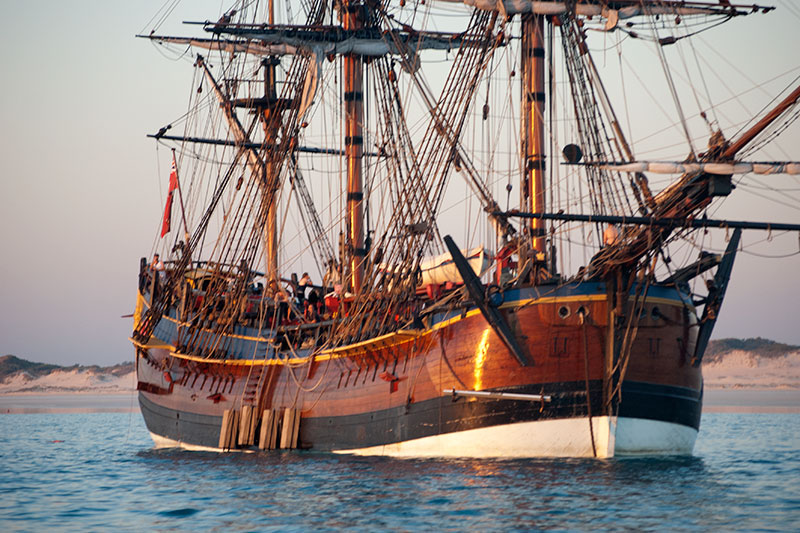


Comments
Post a Comment